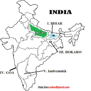
INDIA MAP WORK GEOGRAPHY CLASS 12
भारत मानचित्र कार्य कक्षा -12 भूगोल
(NCERT आधारित)
India - People and Economy Textbook II (NCERT)
Map Items for locating and labelling only on the outline political map of India
Units - 6 & 7,
Ch. 1 to 4
A. State with highest level of urbanization and lowest level Of urbanization
B. One state with highest level of HDI & One lowest level of HDI
C. State with higher level of population density & one state with lowest level of population density
D. One out migrating state E. One in migrating state
F. Any city with more than 10 million population – Greater Mumbai, Delhi, Kolkata, Chennai, Bengaluru
Unit - 8,
Ch. 5 to 9,
A.. Crops:- Leading producing states of the following crops:-
A. Rice B. Wheat C. Jowar D. Cotton, E. Jute F. Sugarcane G. Tea and H. Coffee
B. Mines-:
2. Iron-ore mines:- 1. Mayurbhanj, 2. Bailadila, 3. Ratnagiri, 4. Bellary
3. Manganese mines:- 1. Balaghat, 2. Shimoga
4. Copper mines:- 1. Hazaribagh, 2. Singhbhum, 3. Khetari
5. Bauxite mines:- Katni, Bilaspur and Koraput
6. Coal mines:- 1. Jharia, 2. Bokaro, 3. Raniganj, 4. Neyveli
7. Oil Refineries:- 1. Mathura, 2. Jamnager, 3. Baroni
8. Iron and Steel Plants:- 1. Bhadravati, 2. Bhilai, 3. Bokaro, 4. Durgapur, 5. Rourkela 6. Jameshedpur
9. Cotton Textile:- 1. Surat, 2. Varanasi, 3. Murshidabad, 4. Solapur 5. Coimbatore
10. Software Technology Parks: 1.Gandhinagar, 2. Shrinagar, 3. Mohali,
4. Noida, 5. Indore, 6. Hyderabad, 7. Bengaluru
1. नवीन पाठ्यक्रम के अनुसार कक्षा 12 भूगोल में वार्षिक परीक्षा के अंतर्गत मानचित्र के कुल 2 प्रश्न आते हैं प्रत्येक प्रश्न 5 अंक का होगा कुल 10 अंक के होंगे ।
3. संसार के दिए गए रेखा मानचित्र में पांच भौगोलिक लक्षणों को A, B, C, D, व E से दिखाया जाएगा और नीचे प्रश्नों में दी गई जानकारी के आधार पर लक्षणों की पहचान करें वह खींची गई सरल रेखा पर सही नाम लिखिए।
4. भारत के दिए गए रेखा मानचित्र में नीचे दिए गए प्रश्नों को पढ़कर कोई भी 5 प्रश्नों को उपयुक्त चिन्हों / प्रतिकों से दर्शाए वह उनका नाम लिखिए।
5. नीचे दिए गए मानचित्र पाठ्यक्रम के लगभग संपूर्ण भाग को पूरा करता है।
प्रायोगिक भूगोल कार्य भाग-2 कक्षा-11 RBSE/ CBSE हिन्दी में
6. सभी छात्र अच्छे अंक प्राप्त करने के लिए नियमित रूप से कम से कम 5 से 6 बार मानचित्रों का प्रतीकों या चिन्हों के माध्यम से अभ्यास करें व हल करें ।
7. परीक्षा में मानचित्र प्रश्न के अलावा मानचित्र आधारित कई प्रश्न पूछे जाते हैं जो अच्छे अंक प्राप्त करने में सहायक होते हैं इसलिए मानचित्र भूगोल का अभिन्न-अंग है
8. भूगोल का अध्ययन करते वक्त मानचित्र को हमेशा साथ रखना चाहिए ताकि नियमित रूप से अभ्यास होता रहे और भूगोल को समझने में आसानी होगी
WORLD MAP WORK GEOGRAPHY class 12
धन्यवाद
👇👇👇यहाँ से download करें👇👇
सिविल सेवा की समग्र तैयारी
1. According to the new syllabus, under the annual examination in Class 12 Geography, a total of 2 questions come from the map, each question will be of 5 marks and the total will be of 10 marks. 2. There will be a question of 5 marks from the each book Fundamentals of Human Geography and India's people and economy.
3. In the given line map of the world, five geographical features will be shown from A, B, C, D, and E, and based on the information given in the questions below, identify the symptoms. Write the correct name on the simple line drawn. .
4. After reading the questions given below in the given line map of India, write any 5 questions with appropriate symbols and write their names.
5. The map below completes almost the entire section of the course.
6. All students regularly practice and solve maps at least 5 to 6 times through symbols to get good marks.
7. Apart from the map questions in the exam, many map based questions are asked which helps you to get good marks, hence the map is an integral part of geography.
8. While studying geography, the map should always be kept together so that it is practiced regularly and it will be easy to understand geography.
BOOK-01: Fundamentals of Human GeographyChapter 1. Human Geography Nature and Scope.
Chapter 2. The World Population (Distribution, Density and Growth).
Chapter 3. Population Composition.
Chapter 5. Primary Activities.
Chapter 7. Tertiary and Quaternary Activities.
Chapter 8. Transport and Communication.
Chapter 9. International Trade.
Chapter 10. Human Settlements.
BOOK- 02: India People and Economy
Chapter 1. Population: Distribution, Density, Growth and Composition.
Chapter 2. Migration: Types, Causes and Consequences.
Chapter 5. Land Resources and Agriculture.
Chapter 7. Mineral and Energy Resources.
Chapter 8. Manufacturing Industries.
Chapter 9. Planning and Sustainable Development in Indian Contex.
Chapter 10. Transport And Communication.
Chapter 11. International Trade.
Chapter 12. Geographical Perspective on Selected Issues and Problems.
MAP WORK .
Practical file work .
1. Practical file work ( English medium )
Chapter 1. Human Geography Nature and Scope.
Chapter 2. The World Population (Distribution, Density and Growth).
Chapter 3. Population Composition.
Chapter 5. Primary Activities.
Chapter 7. Tertiary and Quaternary Activities.
Chapter 8. Transport and Communication.
Chapter 9. International Trade.
Chapter 10. Human Settlements.
BOOK- 02: India People and Economy
Chapter 1. Population: Distribution, Density, Growth and Composition.
Chapter 2. Migration: Types, Causes and Consequences.
Chapter 5. Land Resources and Agriculture.
Chapter 7. Mineral and Energy Resources.
Chapter 8. Manufacturing Industries.
Chapter 9. Planning and Sustainable Development in Indian Contex.
Chapter 10. Transport And Communication.
Chapter 11. International Trade.
Chapter 12. Geographical Perspective on Selected Issues and Problems.
MAP WORK .
Practical file work .
1. Practical file work ( English medium )


0 Comments
Post a Comment
Please do not enter any spam link in the comment box.